Esri recently hosted our annual Federal GIS conference. Experts from across National, Regional, and Local governments attend to learn and share their work using spatial analysis to evaluate and implement effective policies. This was our largest ever conference, a welcome reconnection with people after a few years of the pandemic.
The conference kicks off with a plenary session where organizations highlight their mission and how our technology helps them work together to achieve better outcomes. I find these stories inspiring in the dedication of the people on important problems facing society – from Wildfire response to Climate Change to Humanitarian Response and hundreds of other missions.
In particular to my and my teams’ work, I learned about several examples of ArcGIS Hub to share information and coordinate ad-hoc collaboration. I want to highlight a few, you can watch the videos to hear their stories directly.
U.S. White House Climate Resilience
The U.S. White House showcased the recently launched Climate Mapping for Resilience and Adaptation (CRMA), a Hub for anyone to understand local climate impacts. Visitors can explore extreme heat, drought, wildfire, flooding, and other hazards.
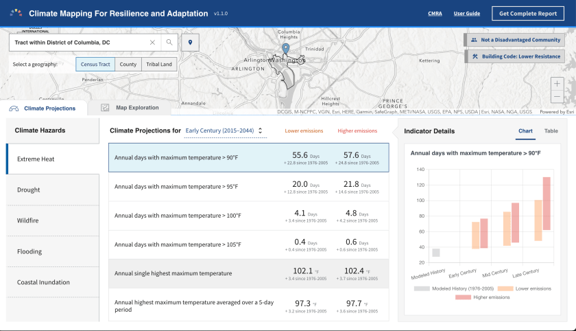
All of the data are open data with a Developer API, download in common file formats, or explore directly in their Hub.

watch the White House video here.
Disaster Response
The Civil Air Patrol received the “Making a Difference Award” for their work coordinating 60,000 volunteers across the country to fly planes, capture imagery and other data, then share it with responders and governments. They publish their information with CAP Geospatial Hub that supports collaboration across Government agencies, volunteers, and partner organizations.

The National Interagency Fire Center (NIFC), part of the U.S. Department of Agriculture might be the first presenter to carry an axe!

The Fire team manages a NIFC Hub for sharing Open Data that is used during fire responses, mostly from mobile devices, to coordinate response locations, actions, and shelters. They moved from paper maps to digital maps to have the most recent information which saves lives and improves response.

Watch the National Interagency Fire Center video
US State Department
The U.S. State Department Bureau of Conflict & Stabilization Operations is actively monitoring the invasion of Ukraine. They use several ArcGIS products including ArcGIS Enterprise Sites, the self-hosted version of ArcGIS Hub, to share sensitive information between analysts, governments, and trusted partners to understand and document atrocities and plan reconstruction.

The Conflict Observatory is a publicly accessible part of their Hub for sharing open data and information to raise awareness and influence diplomacy.

Watch the U.S. State Department video
Local + Regional Governments
While the Esri Federal GIS conference highlights Federal Agencies, many local and regional governments participate. The State of Georgia showcased how they used Hub to manage their 2022 Election and reporting, and I heard from many other local governments that are growing their Hubs based on local policies.
During a technical session, the city of Washington, D.C. walked through their process to develop a Vision Zero Initiative Hub. Linda Bailey, Vision Zero Director for DC, and Kevin McMaster of SymGeo provided pragmatic examples for quickly building, iterating, and launching a Hub driven by executive mandate, data-driven policies, and effective community engagement. You can read more about the details on their case study.

These were just a few highlights from the conference. You can explore more ArcGIS Hubs from around the world in our Hub gallery.